 |
|||
|
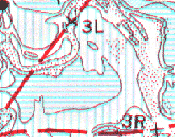
Just look at the difference between the old
map and the new Kentucky Hydrografx map
|
|||
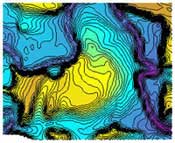
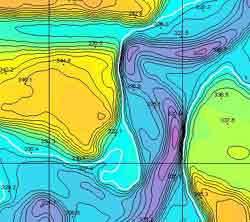
Lake maps are one of the best tools a
fisherman can have to increase his chances for success. New
technologies are making it possible to greatly increase the accuracy and
reveal many subtle depth changes that were previously undetectable. Until
now, even the best maps on the market could only show 5 foot depth
changes. Lots of time on the water and advanced terrain modeling software The wide open areas of Big Sandy and the main river are ideal spots to use these maps. Drop-offs abound in this part of the lake and many are difficult if not impossible to find without a good map. GPS mapping software will allow you to print out exact copies of the underwater terrain that you are targeting on any specific day. If you want to really get all of it's benefits, you can then add a gps for finding new spots and even a palm-sized computer to view the entire area in real time while you are fishing. 3-D images are provided to give you the most intricate view of the creek channels and ledges.
3-D Imaging Included Hundreds of spot elevations are also included on all section maps for easy reference. If you know the current lake elevation, then water depth can be easily calculated.
Prices range from $15.00-$35.00 per CD
|
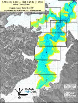
The map above shows the areas available on the Big Sandy River CD
Topographic images on CD each contain a latitude and longitude grid and coordinates for easy calibration with GPS mapping software.
|
||
|
|
|||
|
To Order These Maps
or
Or Call: |
|||

Click Here For Page design and all contents property of:
Parislanding.com |
|||